|
After just a few hours of sleep, we got up and packed our bags, preparing to leave Playa Grande. Before we left though, Chris took us into the Bodega, a small building in the backyard of the station, to see some hatchlings that were coming out of their eggs at that very moment. The eggs had been salvaged through excavations on the beach and in the Hatchery, and the first cracks in them began to appear the night before. We watched with amazement as the tiny little leatherbacks emerged from their shells. Incredible to think that these little creatures will someday grow up to be 1,000-pound beasts (if they are able to survive the many challenges that lie ahead). 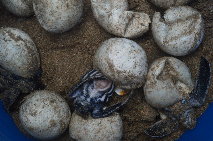 Leatherback hatchlings begin to emerge from their eggs We went for our last breakfast at Kike's, feeling a sad melancholy that this exciting adventure was coming to an end. We said goodbye to the biologists Nathan, Lindsay, Shannon, Jenell, and Heather, then jumped in the van with Chris and Arie to go to the airport in Liberia. It took about an hour, retracing the route we had come in on just nine days earlier. It went by so fast, yet seemed like the routine at Playa Grande had become our way of life. Chris and Arie dropped us off at the airport in Liberia, where I said goodbye to my fellow volunteers Laura, Alvin, and Sally. Bill had gone a fishing trip that morning, so I had said goodbye to him the night before. I then picked up a rental car and began a three-day road trip to see a little bit more of Costa Rica. From Liberia, I drove down to Santa Cruz and then onto a small road that led to the little village of Guaitil. This town is known for its pottery and is also the center of what remains of the Nicoya Chorotega culture. This indigenous people flourished here for thousands of years before the arrival of the Spanish and formed the most important cultural area between the Mayas to the north and the Incas to the south. The town is tiny, centered around a grassy plaza that doubles as a soccer pitch. I walked around, exploring the many pottery shops, and bought a few nice pieces for my collection. 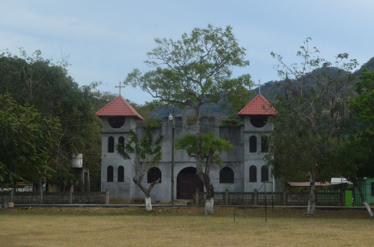 The church on the plaza in the little village of Guaitil From Guaitil, I drove back to Santa Cruz, then further south to Nicoya. I turned east to cross the new Tempisque Bridge at the northern end of the Gulf of Nicoya. This bridge has really opened up the Nicoya Peninsula, replacing a limited ferryboat service and cutting the driving time to the peninsula by several hours. I continued east and soon reach the Pan-American Highway, the main north-south highway through Costa Rica and one which runs from Alaska to Patagonia. On the Pan-American Highway, I turned north to Cañas, then east on a smaller highway up into the highlands of the Cordillera de Tilarán. At this point, I began to see and feel a change in the topography of the land. Gone were the dry, dusty fields of the Guanacaste lowlands; I was gradually coming into lush, green jungle. It was noticeably cooler as well, with gentle breezes that soothed my sun-scorched skin. I stopped for the night at Puerto San Luis, the first town that I came to on the shores of the Lago Arenal. This massive reservoir, the largest lake in Costa Rica, was constructed in 1973, flooding several small towns in the process, and now provides drinking water for Guanacaste Province. The hotel was quiet and mostly empty; it seems like the high tourist season that I saw at Tamarindo has already passed in this area. I got a good night's sleep and prepared for the next day of volcanic beauty. |
||||
|
||||
|
© 2015 Michael Hanrahan
|