|
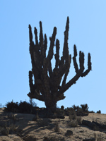
Journey of 1,000 Kilometers: Pan de Azucar National ParkA long day of driving today, into the heart of the Atacama Desert. I traveled through some spectacular desert landscapes, but also through some massive construction zones, where traffic was backed up behind long lines of trucks. I left Punta de Choros early in the morning and picked up a couple of hitchhikers at the edge of town. Rosa, along with her four-year old daughter, was on her way to visit her son, who was studying at a boarding school in Trapiche. She talked about how grateful she was for the education that the government was providing for her son, free of charge, including full room and board. Education is a hot topic in Chile these days, as pressure is mounting to roll back the Pinochet-era privatization of schools that has made a quality education out of reach for the average Chilean. There have been ongoing protests in the streets of Chilean cities over the past few months, and a growing student movement is pushing the issue throughout the country. The graffiti on the city walls reflects the passion incited by this issue: "¡Libre Educación Ahora!" Rosa felt she was very lucky to have this opportunity for a free education for her son. 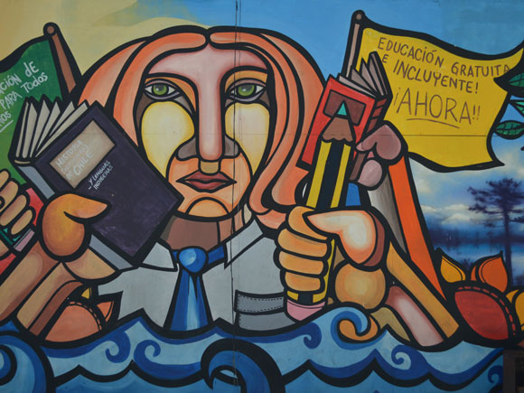 Murals and graffiti throughout Chile advocate free public education for all. The other graffiti throughout the area around Punta de Choros is ¡No a Dominga! I had to ask Rosa what Dominga referred to and she explained that it is a big copper mine proposed in an area near La Higuera, about 26km from Punta de Choros. Upon further research, I found out that a consortium of Chilean financiers want to dig "the biggest hole in the world" and build a new port at Totoralillo Norte. The project would leave a mass of toxic tailings, leach acids into the aquifer in an area where water is in critically short supply, and impact wildlife in the Humboldt Penguin National Reserve. Everyone I spoke with in Chile was opposed to the project and nobody seemed to be enticed by the illusory promise of jobs. After dropping off Rosa and her daughter in Trapiche, I headed north on the Ruta 5. I passed the 700-kilometer marker on the highway, getting further and further north from Santiago. I stopped for gas and groceries in Vallenar, a small city that is the capital of Huasco Province. I went to a very humble restaurant on the main street and had a lunch of Cazuela de Ave - chicken soup with pieces of meat, potatoes, green beans or peas, rice or noodles. Then I stopped at a fruit stand and picked up a cherimoya, which made for a very sloppy but delicious dessert. The land here is beautiful, but the small towns and cities reveal a poverty that is heartbreaking. Clusters of shacks are cobbled together from materials salvaged in any way possible: old plywood, pieces of corrugated metal, oil drums, plastic sheeting. The miners in these settlements have some of the most dangerous, back-breaking, low-paying jobs in the world. Most of the people I've seen in the past few days are men, migrants from other parts of Chile who have come here to make a living and send money back to their families. I continued north on the Ruta 5 through long stretches of empty, starkly beautiful desert. I took a connecting highway that bypasssed Copiapó, is a big city surrounded by some of the richest copper mining areas in the world. It was near here that 33 trapped miners were rescued in 2010, after spending 69 days half a mile underground. North of Copiapó the highway connects back with the Ruta 5 and turns west to the sea, coming upon the coast at Caldera. The landscapes here are jaw-dropping, with a combination of raw desert and rugged rocky coast. But just north of Caldera was another big construction project that stretched on for about 40 kilometers. 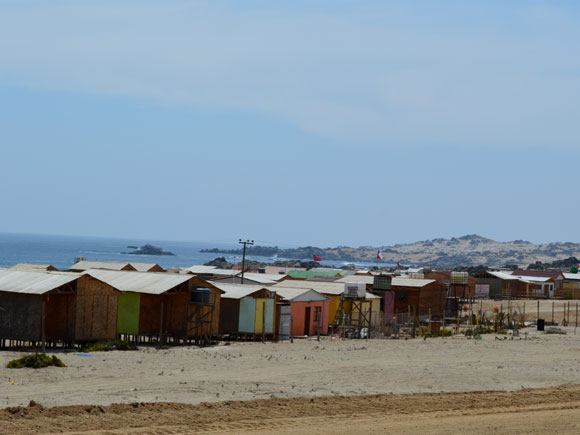 Waiting in traffic north of Caldera, looking out at a small población.
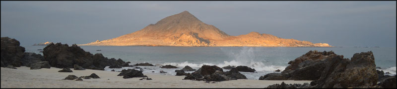
I sit for about 20 minutes in a long line of trucks waiting for a flagman to give the Siga sign, allowing us to continue. Vendors from the nearby población walk along the stopped traffic, selling pan amasado, sweets, and some of the locally produced charqui, a smoked meat jerky. I buy some homemade bread, slightly different from pan amasado, that is sweet and delicious. The traffic gets moving again, only to reach a couple more backups. Finally things open up and the construction area is behind me. The scenery gets even more spectacular as I approach Chañaral, a small town at the southern entrance to the Parque Nacional Pan de Azucar. Pan de Azucar literally means "sugar bread," much like the rich homemade bread I bought from the vendor at the traffic stop. But the historical origin of the word refers to an old way of packaging sugar in a conical shape that was known in English as a sugarloaf. The easily identifiable conical shape has resulted in this word being given to geographical features around the world. Sugarload Mountain in Rio de Janeiro (Pão de Açúcar in Portuguese) and Sugarloaf Mountain in Sonoma, California are just two examples. Here the name is given to an island just off the coast, a semi-symmetrical pyramid that rises above the Caleta Pan de Azucar. I camped that night on the beach, in the small campground near Caleta Pan de Azucar. I made myself a simple dinner of pan amasado, queso de cabra, and white wine, then enjoyed a beautiful sunset. Later the fog came in and the nighttime air turned cold and damp, so I retired to sleep in the car. Not the most comfortable sleep, but it motivated me to get up early and take in the beauty of this place in the morning. As the sun rose on this Atacaman beach, a break in the clouds let a ray of light shine through, directly on the Isla Pan de Azucar. The island was lit up like a beacon, while the seas around it were still shrouded in a foggy mist. Another beautiful day in the desert. |
||||||||||
|
|||||||||||
 |
|||||||||||
|
© 2015 Michael Hanrahan
|
|||||||||||